Thousands of Sinkholes Every Year in Mexico.
They Can Be Prevented.
Sinkholes strike without warning. They cause property damage, public fear, and many have claimed lives. But the causes are known, and there are countries that have reduced this phenomenon by 81% through prevention and discipline.
We have studied this problem thoroughly. The result is a comprehensive sinkhole prevention plan designed for municipalities, covering every stage: from early detection to supervised repair.
A growing phenomenon that no one is measuring
Mexico has no national sinkhole registry. Nobody knows how many occur each year. But the data that does exist is alarming:
Puebla Case 2021
A sinkhole in Santa Maria Zacatepec appeared with a 5-meter diameter on May 29. In just 12 days it grew to 110 meters in diameter and 15 meters deep, destroying a home. Cause: over-exploitation of the Alto Atoyac aquifer. An InSAR satellite monitoring system would have detected the subsidence months before the collapse.
The main causes are well known:
Water gradually erodes the subsurface until the ground gives way.
Pipes over 50 years old that fracture and collapse.
Excessive pumping generates regional subsidence that weakens the ground.
Excavations that alter the ground balance without prior study.
Soil saturation accelerates the formation of underground cavities.
Natural geological conditions that favor ground dissolution.
Other countries have already solved this
We are not inventing anything new. These programs already work, are well documented, and have measurable results. Mexico can learn from them.
Result: from 57 sinkholes in 2016 to 11 in 2021 — an 81% reduction. They scan 7,169 km of roadways per year with vehicular GPR, with a target of 18,000 km. Monthly inspections in excavation zones and weekly in major construction sites.
Backed by the Special Act on Underground Safety Management (2016).
Publishes annual road collapse statistics spanning decades. The Sewerage Act reform requires minimum inspection every 5 years on high-risk segments. Fukuoka repaired a 30-meter sinkhole in just 6 days (2016).
Digital platform integrating data from hundreds of underground asset owners and millions of km of networks. Backed by the Data (Use and Access) Act 2025. The BGS has over 10,000 sinkholes documented in its karst database.
Following the Nicoll Highway disaster (2004), comprehensive underground safety reforms were implemented. Real-time monitoring with machine learning. Mandatory verification before any excavation.
The common denominator: all these countries combine detection technology (GPR, InSAR), centralized databases, mandatory periodic inspections, and a legal framework that assigns responsibilities. The technology is the same that Cartomex has been using for over 20 years.
Sinkhole Prevention Plan for Municipalities
A practical 6-stage plan covering everything from understanding the problem to supervised repair. Designed so that any municipality can implement it.
Historical knowledge: Sinkhole database
You cannot prevent what you do not understand. The first step is knowing where sinkholes have occurred before, how frequently, and for what reasons.
Cartomex has built the largest sinkhole database in Mexico: over 115 GB of information collected from Facebook (105 GB of citizen reports), X/Twitter (9.36 GB of alerts), and news media (1.06 GB of articles). All geolocated and categorized.
Timely detection: Regular GPR (Ground Penetrating Radar) surveys & satellite monitoring
Once risk zones have been identified, two continuous surveillance systems are deployed working in parallel:
Vehicular GPR
Ground Penetrating Radar mounted on a municipal vehicle that scans roadways detecting cavities, voids, and internal erosion beneath the pavement. The same method Seoul uses to scan 7,169 km per year.
- Municipal staff operate the equipment (1-2 days training)
- Cartomex processes and interprets data remotely
- Depth: up to 8 m (high resolution) or 15 m (confirmation)
- Smart route prioritization based on risk zones
 Multi-sensor trailer: GPR antenna + thermal camera + RGB camera. Attaches to any municipal vehicle.
 In addition to the Ground Penetrating Radar, the cart integrates an infrared thermal camera and a high-resolution RGB camera. The thermal camera detects temperature anomalies on the pavement — cold zones indicating groundwater seepage or voids beneath the surface. The RGB camera documents the visible pavement condition: cracks, potholes, settlements, and premature failures. All three data sources are simultaneously georeferenced to create a comprehensive diagnosis of each road segment.
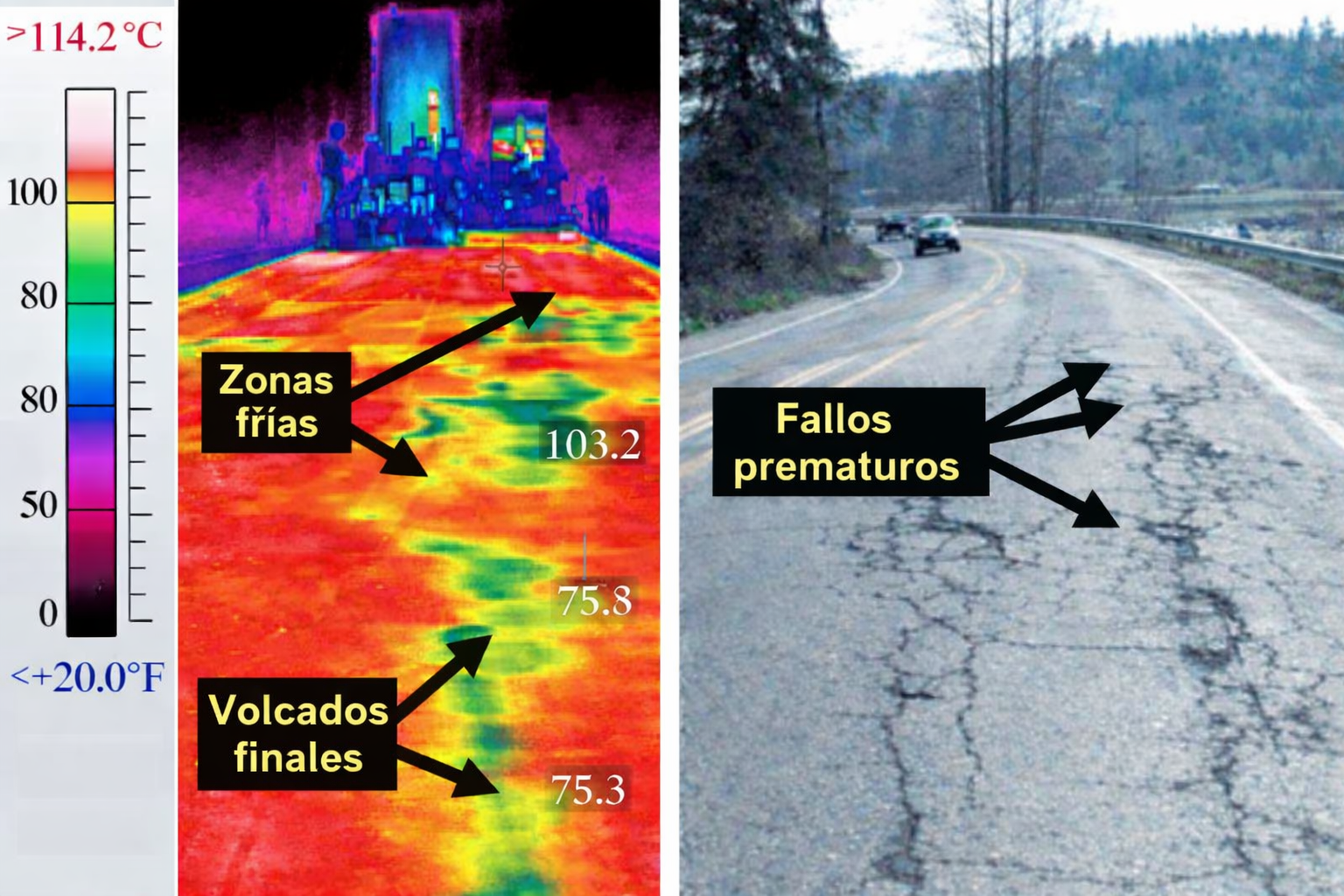 Left: thermal image — cold zones (green/blue) indicate water seepage under the pavement. Right: RGB image — visible premature failures on the surface.
  Actual radargram: hyperbolas reveal buried pipes. Similar anomalies indicate cavities or forming voids.
 InSAR Satellite Monitoring (VialiSAR)
Satellite radar that detects millimetric ground movements that precede sinkhole formation. Early warning without physical presence.
- Broad coverage with no per-kilometer operational cost
- Millimetric precision in vertical displacement
- Continuous quarterly or semi-annual monitoring
- Displacement velocity maps by zone
VialiSAR in action: Miguel Hidalgo Borough
Real-world example using Sentinel-1 data (C-band). The system detected 120 anomalies on roadways: 23 critical, 21 high priority, and 72 recent ponding zones.
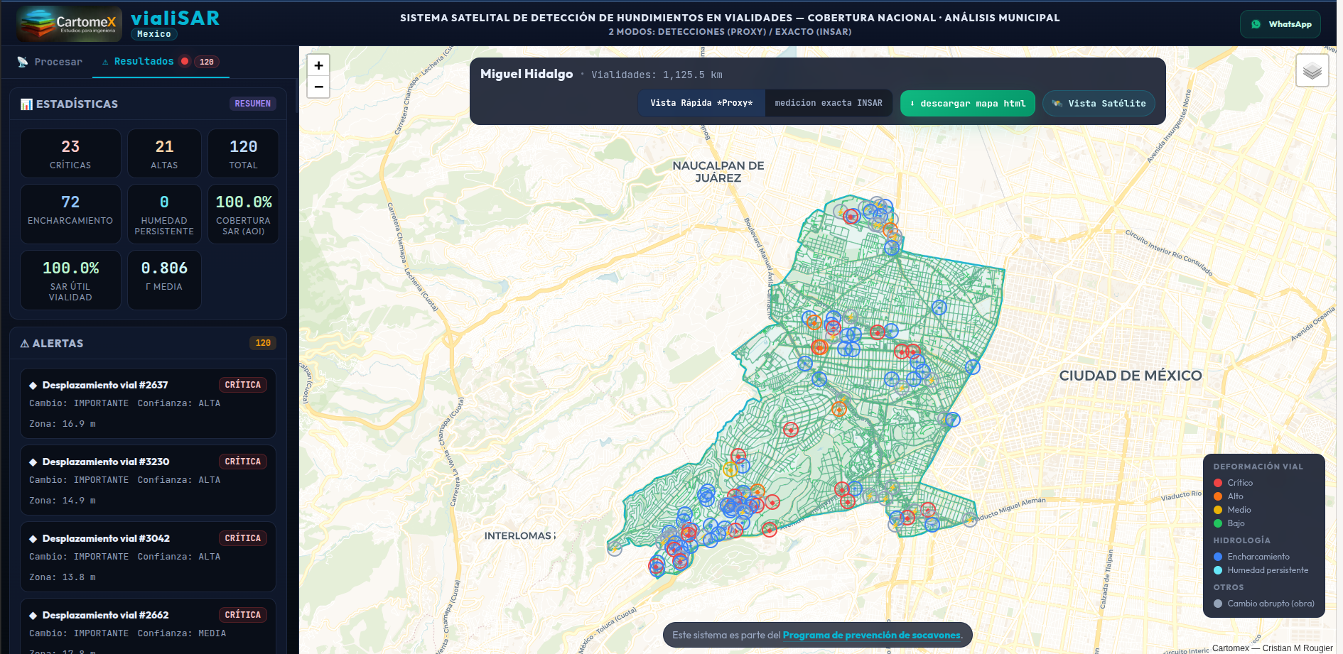 Municipal analysis dashboard: alerts by priority level with real-time statistics.
 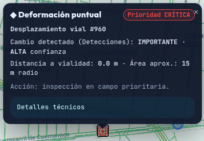 Point deformation — CRITICAL priority. Priority field inspection required.
 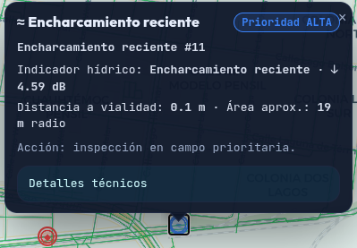 Recent ponding — HIGH priority. Possible precursor of internal erosion.
 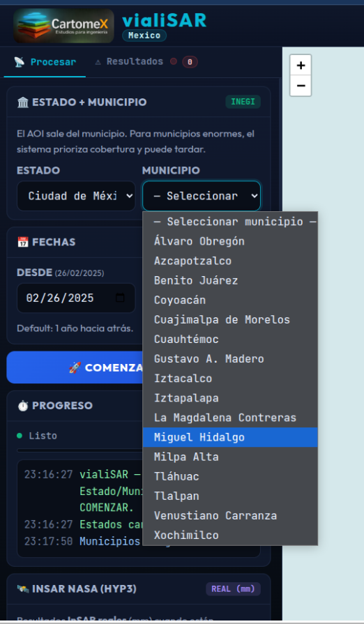 Nationwide coverage. Any municipality in the country can be analyzed.
 Confirmation: Detailed geophysics at detected sites
When vehicular GPR or InSAR identifies an anomaly, confirmation studies are deployed at the specific site to precisely measure the problem:
- Detailed grid GPR survey — Close-grid scanning of the suspicious area to map the exact geometry of the anomaly.
- Electrical resistivity surveys — Electrical tomography to identify changes in soil saturation, water presence, and weakened zones.
Assigned responsible geologist: the GEOPADRINO
Each municipality receives a certified assigned geologist (GEOPADRINO) who acts as the responsible technical authority for the case. This person connects technology to decision-making. Their responsibilities:
- Exploratory pit — Controlled excavation to physically verify subsurface conditions.
- CCTV inspection cameras — Visual inspection of the interior of ducts and cavities with specialized cameras.
- 3D scanning of the underground cavity — Precise volume measurement: how large is it? How many cubic meters?
- Detailed geological report — Documents the cause, current state, collapse risk, and recommended infill or repair strategy.
Supervised intervention and repair
With the GEOPADRINO's diagnosis, the required intervention is executed: grout injection, controlled backfill, duct repair, foundation stabilization, or traffic diversion as needed. Everything is documented and supervised until satisfactory closure.
The cycle continues
Monitoring is permanent. GPR surveys repeat on schedule, InSAR continuously watches from space, and the database is updated with each new finding. Each cycle improves the accuracy of the municipality's risk map.
Where to start? Prioritization based on real data
Monitoring routes are not chosen at random. They are prioritized based on the historical database and proven risk criteria:
| Priority | Zone | Reason |
|---|---|---|
| HIGH | Areas with sinkhole history | Proven recurrence from historical data |
| HIGH | Zones near new construction during rainy season | Subsurface disturbance + water saturation |
| HIGH | Areas near flood zones | Accelerated internal erosion of the subsurface |
| MEDIUM | Main roadways and high-traffic routes | Greater potential impact in case of collapse |
| MEDIUM | Zones with aging drainage infrastructure (>30 years) | Progressive pipe deterioration |
What does the municipality need and what does it receive?
What the municipality invests
- Purchase or rental of GPR equipment with vehicular accessory
- Dedicated personnel for survey routes (no specialization required)
- Periodic data delivery to the processing center
What it receives
- Historical risk map of the municipality (+115 GB of data)
- Professional GPR data processing
- Alerts for potential early-stage sinkhole formation
- On-site confirmation geophysical surveys
- Assigned geologist (GEOPADRINO) with diagnosis and action plan
- VialiSAR satellite monitoring of roadways
- Repair supervision until case closure
The Law That Reduced Sinkholes by 81%
South Korea enacted in 2016 the Special Act on Underground Safety Management (지하안전관리에 관한 특별법). We are not politicians or government officials, but we share this law as a technical reference because its results are undeniable. These are its key points:
National Master Plan every 5 years
The Ministry of Infrastructure establishes a master plan for underground safety with objectives, technologies, and budget. Each province and municipality prepares its own annual plan aligned with the national one.
Mandatory assessment before excavation
Any construction involving excavation deeper than 10 meters requires an Underground Safety Impact Assessment. Works deeper than 20 meters require a full assessment. Construction cannot begin until the assessment is approved.
Certified specialized agencies
Only registered companies meeting capital, equipment (including GPR), and qualified technical personnel requirements can perform assessments. Falsifying data or copying reports from other projects is prohibited. Penalty: registration cancellation.
Periodic facility inspections
Water, gas, electricity, metro, and telecommunications administrators must periodically inspect their facilities and the surrounding ground. If they discover a cavity, they must repair it and immediately report to authorities.
Emergency protocol with investigation committee
Any sinkhole larger than 1 m2 with 1 m depth must be reported. Severe accidents (4 m2 or more, 3+ victims) activate a Central Investigation Committee with powers to inspect records, interrogate responsible parties, and request police assistance.
3D subsurface map and information system
A three-dimensional integrated map of all underground facilities, geological structure, and groundwater is maintained at the national level. Accident data, assessments, and inspections are centralized in a single information system.
Real penalties for negligence
Up to 3 years in prison for leaking confidential information. Up to 2 years for failing to perform mandatory assessments or falsifying reports. Fines up to 30 million won (~$23,000 USD). The company is also liable if the employee acts negligently.
81% reduction in Seoul
With this law as backing, Seoul went from 57 sinkholes in 2016 to 11 in 2021. They scanned 33,129 km with GPR and detected 7,760 cavities that were repaired before they collapsed. The evidence is clear: prevention works when it is institutionalized.
Cartomex has the complete Spanish translation of all 52 articles of this law. Available for consultation by municipalities, legislators, and organizations interested in establishing a similar framework in Mexico. Request a copy →
Implementation phases
A plan that is implemented progressively, starting where it hurts the most.
Phase 1: Pilot
Municipalities with the highest sinkhole history. Validation of the complete operational cycle and first documented success case.
Phase 2: Expansion
Scale to high-risk municipalities nationwide. Building the GEOPADRINO network and consolidating the system.
Phase 3: National coverage
Consolidated national system. Mexico as a regional reference in sinkhole prevention.
Prevention costs less than repair.
And it saves lives.
Schedule a presentation with data specific to your municipality. We will show you the sinkhole history in your area and how to implement the plan.