Over 20 years online have taught us something: quotes are needed fast. That's why we deliver a proposal within 1 hour. Use our service forms for best results.
GSSI® is a registered trademark of Geophysical Survey Systems, Inc.
Own a GSSI radar and need help processing your data? At Cartomex, we provide professional processing and interpretation of .dzt files from any GSSI equipment. Whether you use a SIR 4000, UtilityScan, StructureScan or BridgeScan — send us your files and we'll deliver processed radargrams with a clear, professional interpretive report.
GSSI (Geophysical Survey Systems, Inc.) is the world's largest GPR manufacturer, with thousands of systems in operation globally. But owning the equipment doesn't always mean having the expertise to interpret the radargrams. If you need an expert who can give geophysical meaning to your data, this service is for you.
Real Example: Before and After Processing
Here's how we transform raw GSSI data into interpretable information:


Data acquired with GSSI SIR 4000. Left: unprocessed .dzt file. Right: processed radargram with subsurface anomaly interpretation. © Cartomex.
GSSI Systems We Process
We process data from all GSSI systems, including:
| System / Configuration | Primary Application | Format |
|---|---|---|
| UtilityScan / UtilityScan Pro / UtilityScan DF | Underground utility locating | .dzt |
| StructureScan Mini XT / Mini LXT / Pro | Concrete inspection, rebar locating | .dzt / .3dz |
| BridgeScan | Bridge deck deterioration assessment | .dzt |
| SIR 4000 / SIR 30 | Multi-purpose control units with any GSSI antenna | .dzt |
| SIR 3000 / SIR 20 (legacy) | Earlier systems, still in operation worldwide | .dzt |
| PaveScan RDM 2.0 | Asphalt density assessment | .dzt |
| Flex NX / Flex LT | Next-generation concrete scanning | GSSI digital format |
| Individual antennas (400, 270, 200, 900, 1600, 2600 MHz) | Custom setups via SIR 4000/30 | .dzt |
Have an older GSSI system? If your radar recorded .dzt files, we can process it. We've worked with GSSI data dating back to the 1990s.
What We Do With Your GSSI Data
We're not a RADAN alternative — we're the step that comes after software. Any software can apply filters to a radargram. We give geophysical meaning to every reflector, hyperbola and anomaly in your data.
1. Data Reception & Verification
We receive your .dzt files (and .dzx if GPS is available). We verify integrity, trace count, time window, antenna frequency and acquisition settings.
2. Professional Processing
We apply the appropriate processing sequence: time-zero correction, gain adjustment, bandpass filtering, background removal, migration where applicable, and velocity calibration for accurate depths.
3. Geophysical Interpretation
Every identified reflector receives an interpretation: pipes, cables, voids, soil interfaces, water table, fill material, bedrock — whatever the project context indicates.
4. Deliverables
Processed and interpreted radargrams in digital format plus a technical report. With GPS or control points available, we include georeferenced plans. Grid data gets depth slices.
Who Is This GSSI Processing Service For?
UtilityScan Operators
You can mark in the field but need a professional report for your client. Or you have complex data with multiple utilities and need an expert second opinion.
Engineering Firms
You purchased or rented a GSSI for a specific project but don't have a geophysicist on staff. We process and interpret your data.
Researchers & Academics
You need professional processing for publications, theses or technical reports. We deliver with the rigor that academic contexts require.
Utility Locators
You use your GSSI daily to mark utilities, but a client requests a detailed report with interpretation. We create it for you.
Portfolio: How We Deliver Our Work
Real project example: airport runway evaluation with GPR. These are the types of deliverables you receive when you hire our processing service.

Radargrams with Detailed Interpretation — Every identified anomaly classified: hyperbolas (objects/voids), discontinuities, asphalt layer interfaces.
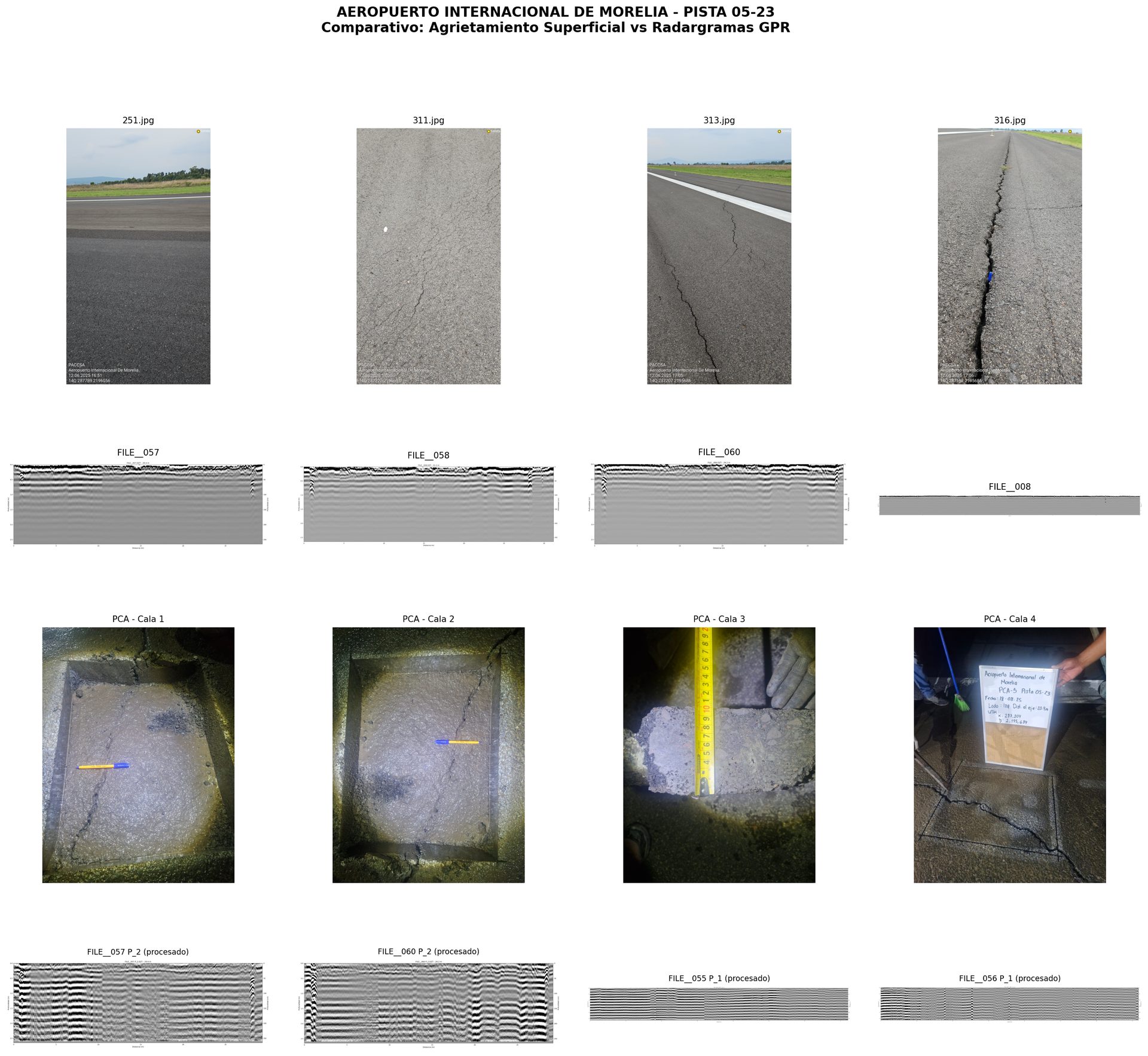
Surface-Subsurface Correlation — We compare visible surface conditions with GPR subsurface data and verification cores.
Project: Airport runway evaluation. GSSI data processed and interpreted by Cartomex. © Cartomex.
Have GSSI Data That Needs Processing?
Tell us about your project. To provide a quote we need: your GSSI model, approximate number of lines and total length, the survey objective, and whether you have GPS data.
Haven't done your survey yet? Read our GPR Survey Field Guide — it will help you collect better data, and we'll deliver better results.